
|
| Home | Mapping Services | Aerial Photography | Photogrammetry | About Us | Technical info | For Sale | Clients | Contact us |
Aerial Surveys and Photography
The quality of an aerial photo is largely determined by the optical quality of the camera lenses. The lenses of the Zeiss RMK TOP offer maximum resolution and freedom from distortion. Film is developed with an AGFA Gevaltrone 66 processor. Diapositive and
paper photographs are made on an Egoltronics vacuum printer. |
| San-Lo Aerial Surveys, 1130 D Street, Suite 7, Ramona, CA 92065-0543 Tel: 858-565-1024 Email: 460san-lo@san-lo.com 460san-lo@san-lo.com |
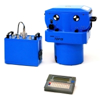 We
are pleased to offer our customers the most up-to-date technology offered
by our new -July 2007- aerial survey camera system, the Zeiss RMK TOP.
The RMK represents a new camera generation, responding to increasing demands
in application and new technology.
We
are pleased to offer our customers the most up-to-date technology offered
by our new -July 2007- aerial survey camera system, the Zeiss RMK TOP.
The RMK represents a new camera generation, responding to increasing demands
in application and new technology.