|
| Home | Mapping Services | Photogrammetry | About Us | Technical info | For Sale | Clients | Contact us |
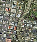
Aerial Surveys, Digital Photogrammetry and Aerial PhotographySan-Lo Aerial Surveys is a California Corporation founded in January 1968. The company specializes in precision Digital Photogrammetry providing topographic mapping and aerial photography services in the southwestern United States.
Aerial surveys are a non-intrusive surveying method that can provide usable and flexible 3D data and photographic records. Aerial surveys are accurate, cost effective and useful tools for:
Contact us to learn more about our mapping services, or find out more about San-Lo Aerial Surveys. |
| San-Lo Aerial Surveys, 1130 D Street, Suite 7, Ramona, CA 92065-0543 Tel: 858-565-1024 Email: 460san-lo@san-lo.com 460san-lo@san-lo.com |